PREV ARTICLE
NEXT ARTICLE
FULL ISSUE
PREV FULL ISSUE
COIN HOARDS AND GOOGLE MAPS SHOW ANTIOCH'S INFLUENCE
Arthur Shippee forwarded this article about how coin hoards and Google Maps help illustrate Antioch's influence. Thanks!
-Editor
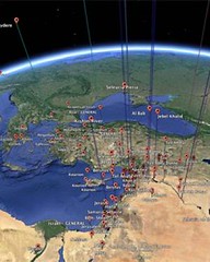
With the swipe of a finger, the University of Cincinnati's Kristina Neumann can zoom along the boundaries of ancient Antioch during the beginning of Roman takeover thanks to the modern cartography of Google Earth software. The simplicity with which she flicks across the Middle Eastern landscape belies the depth of information available at her fingertips and the effort that's gone into her research. "I trace the process of change by working with historical proxies, in this case coins," says Neumann, a doctoral candidate in the McMicken College of Arts & Sciences Department of Classics. "I created my own database from previously published excavation reports and lists of coin hoards, and imported it to Google Earth. My criteria are so detailed that I can see all the coins for a particular emperor or of a particular material." She hopes this visual, interactive way of presenting the ancient world inspires other historians to get more creative in today's "there's an app for that" world. "I'm trying to help historians think outside the box," Neumann says. "There's a huge movement in the digital humanities in general, and this research speaks to that. Using tools such as Google Earth to visualize the ancient world could also have ramifications for how we look at data today." Neumann will present her research "Using Google Earth to Visualize an Ancient City's Influence: Roman Antioch" at the Archaeological Institute of America and American Philological Association Joint Annual Meeting to be held Jan. 2-5 in Chicago. The meeting attracts more than 3,000 international attendees to share news and ideas among the top archaeological and classical scholars. In ancient times, much like now, authorities determined which foreign currency was accepted in a community. For Neumann, this made coins an ideal representation of a political relationship among cities. For example, if lots of Antiochene coins were discovered in a neighboring city, it's likely a political agreement existed between the two governments. Coins were also a data-rich resource for Neumann. In addition to tracking where the coins were found, she cataloged critical information about a coin – such as when it was minted and under whose authority it was made – that has been derived from the images and inscriptions imprinted on it. Other artifacts, like pottery, were less likely to have such identifiers. Neumann uses Google Earth to convert the vast information in her coin database into a visual representation of Antioch's political borders. She analyzes how the software plots which coins were found where and in what quantity across different historic time periods. This way she can follow the transformation of Antioch's political influence as it was absorbed by the Roman empire.
To read the complete article, see:
Money talks when ancient Antioch meets Google Earth (w/ Video)
(m.phys.org/news/2014-01-money-ancient-antioch-google-earth.html)
The Numismatic Bibliomania Society is a non-profit organization promoting numismatic literature. See our web site at coinbooks.org. To submit items for publication in The E-Sylum, write to the Editor at this address: whomren@gmail.com To subscribe go to: https://my.binhost.com/lists/listinfo/esylum All Rights Reserved. NBS Home Page Contact the NBS webmaster 
|
